


Mobile Topographer Free


Beschreibung von Mobile Topographer Free
Your mobile Topographer!
The leading tool for the professional surveyor or anyone who wants to mark his property, offering the best accuracy and extensive functionality that no other app can!
*** Increase GPS accuracy using:
- Weighted averaging (on every axis).
- Map calibration.
- Device calibration on map, or on a know point.
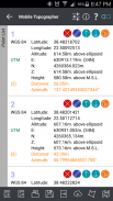
*** Display and convert GPS geodetic to Cartesian EN coordinates and back:
- UTM.
- Europe ETRS89/UTMZ28-38.
- Hellas HGRS 87 (EGSA 87).
- Hellas HGRS 87 - HEPOS.
- Hellas HTRS07/TM07.
- Iceland ISN93/Lambert 93.
- Morocco Merchich.
- SPCS83 (124 zones) USA.
- Romania S-42(58)/Stereo 70.
- Lebanon & Syria Deir ez Zor/Stereo.
- Croatia HTRS96/TM.
- Serbia SRB-ETRS89/UTM, SRB-MGI/Z7.
- Australia MGA94 (GDA94), AMG66 (AGD66) National, A.C.T., Northern Territory, NSW & Victoria, Tasmania,AMG84 (AGD84).
- Former FR of Yugoslavia MGI Balkans zones 5,6 & 7.
- Italy Monte Mario West Zone 1 Peninsular, West Zone 1 Sardinia, East Zone 2 Peninsular, East Zone 2 Sicily.
- Costa Rica CΜ05/CRTM05, Ocotepeque 1935 Costa Rica Norte & Ocotepeque 1935 Costa Rica Sur.
- Cyprus CGRS-93-LTM.
- Hungary HD72/EOV.
- Kosovo KosovaREF01.
- Latvia LKS92/TM.
- Lithuania LKS94/TM.
- Spain ED50/UTMZ29-30 NW, ED50/UTMZ29-31 ML & ED50/UTMZ31 BA.
- Uk's OSTN02/OSGM02.
- Turkey ED50/Gauss-Kruger 3° Z9-15, ITRF96 & ED50/UTMZ35-38.
- Luxembourg LUREF.
- Venezuala REGVEN/Z18-20.
- Sweden SWEREF99 TM.
- Argentina POSGAR 94 & POSGAR 2007.
- India Kalianpur 1975 ZI - ZIV.
- Algeria Nord Sahara 1959 / Z29-32.
- Armenia, Georgia, Azerbaijan, Estonia, Latvia, Lithuania, Russia - Kaliningrad and Kazakhstan Pulkovo 1942/ CS63 (A)Z1-4, (C)Z0-2, (K)Z2-4.
- Central and South America SIRGAS 2000.
- Nigeria and Cameroon Minna 1996 & 2008 MTM West, Mid, East Belts & UTM Z31-33.
- Bangladesh Gulshan 303/TM.
- France RGF93/CC42-50.
- Canada CSRS
- Egypt 1907 Blue, Red, Purple, Extended Purple belts.
- Portugal ETRS89/PTM06.
- Netherlands Amersfoort/RD new.
- Qatar QND95.
- Colombia MAGNA-SIRGAS Far West, West, Bogota, Central East, East zones.
- Mexico ITRF 2008/LCC.
- Madagascar Tananariva (Paris)/Laborde & Tananariva/UTM Z38-39S .
- Tunisia Carthage (Paris)/Mining Grid, Carthage/Nord, Carthage/Sud, Carthage/TM 11 NE, Carthage/UTM zone 32N.
- Liechtenstein CH1903/LV03C-G.
- Switzerland CH1903/LV03 (old), CH1903+/LV95 (new).
- Brazil SAD69/UTM Z18-25 & SAD69(96)/UTM Z18-25
- Spain Canary Islands REGCAN95/LAEA & REGCAN95/LCC & REGCAN95/UTM Z27-28
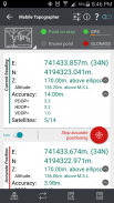
*** Auto stop for accurate positioning.
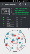
*** Examine the satellites above you in a sky view.
*** Signal strength and number of satellites indication for each GNSS constellation individually.
*** Multiple units support:
- Meters,
- International feet,
- US survey feet.
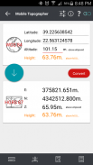
***Height calculation:
- Ellipsoidal height.
- EGM96 orthometric height calculation.
*** Convert from geodetic to Cartesian coordinates and back:
- Support for device measured points, or
- Manually input of geodetic or Cartesian coords.
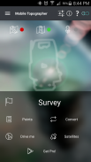
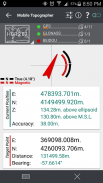
*** Drive me:
- Key in coordinates of the target point in either geodetic or Cartesian coordinates, or select a point from the list and follow the pointer.
- Compass indicating both magnetic and true North.
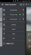
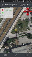
*** Project on Map:
- Project individual points on any map application.
- Project list of points, and the defined polygon, on embedded maps.
*** Save multiple point lists, to use them later.
*** Calculate area.
*** Export point lists το:
- .txt (text file)
- .csv (point file - comma separated)
- .kml (google earth file)
- .gpx (Gps Exchange format)
- .dxf (drawing file)
*** Send file via e-mail, or upload it to cloud.
*** Complete help text support.
Help us improve Mobile Topographer by e-mailing your comments and suggestions.
TAGS: Survey Surveyor Property GPS GNSS GLONASS QZSS BEIDOU GALILEO
Ihr Handy Topographer!
Das führende Werkzeug für den professionellen Landvermesser oder jemand, der will, sein Eigentum zu kennzeichnen, die höchste Genauigkeit bieten und umfangreiche Funktionalität, die keine andere App können!
*** Erhöhen Genauigkeit von GPS verwenden:
- Weighted Averaging (auf jeder Achse).
- Map-Kalibrierung.
- Gerätekalibrierung auf der Karte oder auf einem Know Punkt.
*** Anzeige und konvertieren GPS geodätische zu cartesianischen EN-Koordinaten und zurück:
- UTM.
- Europa ETRS89 / UTMZ28-38.
- Hellas HGRS 87 (EGSA 87).
- Hellas HGRS 87 - HEPOS.
- Hellas HTRS07 / TM07.
- Island ISN93 / Lambert 93.
- Marokko Merchich.
- SPCS83 (124 Zonen) USA.
- Rumänien S-42 (58) / Stereo 70.
- Lebanon & Syrien Deir ez Zor / Stereo.
- Kroatien HTRS96 / TM.
- Serbien SRB-ETRS89 / UTM, SRB-MGI / Z7.
- Australien MGA94 (GDA94), AMG66 (AGD66) National, A.C.T., Northern Territory, NSW & Victoria, Tasmanien, AMG84 (AGD84).
- Der ehemalige FR Jugoslawien MGI Balkan Zonen 5,6 und 7.
- Italien Monte Mario West Zone 1 Halbinsel, West Zone 1 Sardinien, East Zone 2 Peninsular, East Zone 2 Sizilien.
- Costa Rica CΜ05 / CRTM05, Ocotepeque 1935 Costa Rica Norte & Ocotepeque 1935 Costa Rica Sur.
- Zypern CGR-Dateien-93-LTM.
- Ungarn HD72 / EOV.
- Kosovo KosovaREF01.
- Lettland lks92 / TM.
- Litauen LKS94 / TM.
- Spanien ED50 / UTMZ29-30 NW, ED50 / UTMZ29-31 ML & ED50 / UTMZ31 BA.
- Großbritanniens OSTN02 / OSGM02.
- Türkei ED50 / Gauss-Krüger 3 ° Z9-15, ITRF96 & ED50 / UTMZ35-38.
- Luxemburg LUREF.
- Venezuala REGVEN / Z18-20.
- Schweden SWEREF99 TM.
- Argentinien POSGAR 94 & POSGAR 2007.
- Indien Kalianpur 1975 ZI - ZIV.
- Algerien Nord Sahara 1959 / Z29-32.
- Armenien, Georgien, Aserbaidschan, Estland, Lettland, Litauen, Russland - Kaliningrad und Kasachstan Pulkovo 1942 / CS63 (A) Z1-4, (C) Z0-2, (K) Z2-4.
- Mittel- und Südamerika SIRGAS 2000.
- Nigeria und Kamerun Minna 1996 & 2008 MTM West, Mitte, Ost-Gürtel & UTM Z31-33.
- Bangladesh Gulshan 303 / TM.
- Frankreich RGF93 / CC42-50.
- Kanada CSRS
- Ägypten 1907 Blau, Rot, Lila, Lila Erweiterte Gürtel.
- Portugal ETRS89 / PTM06.
- Niederlande Amersfoort / RD neu.
- Katar QND95.
- Kolumbien MAGNA-SIRGAS Far West, West, Bogota, Central East, East Zonen.
- Mexiko ITRF 2008 / LCC.
- Madagaskar Tananariva (Paris) / Laborde & Tananariva / UTM Z38-39S.
- Tunesien Karthago (Paris) / Bergbau Gitter, Carthage / Nord, Karthago / Sud, Karthago / TM 11 NE, Carthage / UTM-Zone 32N.
- Liechtenstein CH1903 / LV03C-G.
- Schweiz CH1903 / LV03 (alt), CH1903 + / LV95 (neu).
- Brasilien SAD69 / UTM Z18-25 & SAD69 (96) / UTM Z18-25
- Spanien Kanarische Inseln REGCAN95 / LAEA & REGCAN95 / LCC & REGCAN95 / UTM Z27-28
*** Auto-Stop für die genaue Positionierung.
*** Untersuchen Sie die Satelliten, die über Sie in einem Blick in den Himmel.
*** Die Signalstärke und Anzahl der Satelliten-Anzeige für jede GNSS Konstellation individuell.
*** Mehrere Einheiten unterstützen:
- Messgeräte,
- Internationale Füße,
- US-Umfrage Füße.
*** Höhe Berechnung:
- Ellipsoidal Höhe.
- EGM96 orthometrisch Höhenberechnung.
*** Von geodätischen zu rechtwinkligen Koordinaten und zurück konvertieren:
- Unterstützung für Gerät gemessen Punkte oder
- Manuelle Eingabe von geodätischen oder kartesischer Koordinaten.
*** Fahr mich:
- Geben Sie Koordinaten des Zielpunktes in entweder geodätischen oder kartesischen Koordinaten oder einen Punkt aus der Liste auswählen und den Zeiger folgen.
- Kompass zeigt sowohl magnetische als auch wahre Norden.
*** Projekt auf der Karte:
- Projekt einzelne Punkte auf jeder Map-Anwendung.
- Projekt Liste der Punkte, und der definierte Polygon, auf eingebettete Karten.
*** Speichern von mehreren Punktlisten, sie später zu verwenden.
*** Bereich berechnen.
*** Export Punktlisten το:
- .txt (Textdatei)
- CSV (Punktdatei - durch Komma getrennt)
- .kml (Google earth-Datei)
- .gpx- (GPS Exchange Format)
- Dxf (Zeichnungsdatei)
*** Senden Datei per E-Mail oder laden Sie sie auf Wolke.
*** Vollständige Hilfetext-Unterstützung.
Helfen Sie uns, Mobil Topographer per E-Mail an Ihre Kommentare und Anregungen zu verbessern.
TAGS: Umfrage Surveyor Property GPS GNSS GLONASS QZSS Beidou GALILEO
Mobile Topographer Free – Version 9.3.2
(22-05-2019)

Mobile Topographer Free – APK Informationen
APK Version: 9.3.2Paket: gr.stasta.mobiletopographerNeueste Version von Mobile Topographer Free
Weitere Versionen


 4.63
4.63


 4.15
4.15Apps in derselben Kategorie

Das könnte dir auch gefallen...


